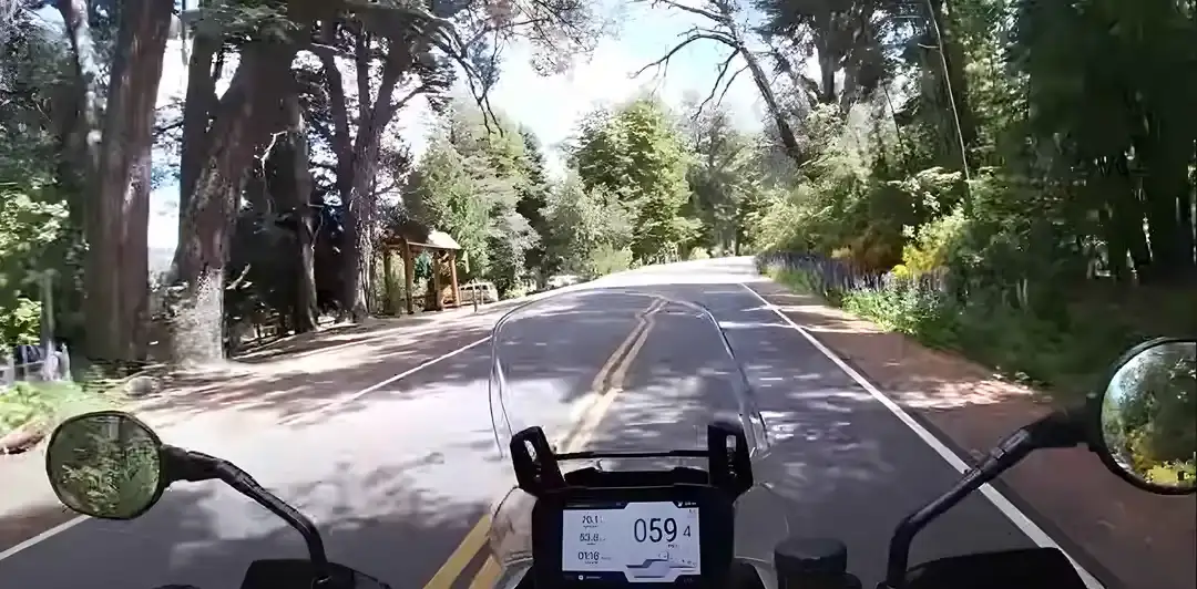
View over the handlebars of a shaded paved road through dense forest
Andean Highlands route

The Cornisa road from Salta to Jujuy: 98 km of yungas cloud forest on Ruta 9

The old road between the two capitals of the Northwest: 70 km of single-lane curves through cloud forest, past La Caldera and the reservoirs, with no straight longer than a football pitch.

South to north, the first riding day of our Andean Highlands loop. Data computed 2026-10-20, notes updated 2026-10-21.

  • 98 km61 miles
  • 78 % paved4 km gravel, 17 km untagged
  • 1,578 mhighest point, 910 m of climbing
  • 39 fuel stopslongest gap 64 km
  • 1.5 to 1.5 hriding time, stops not included
  • 0 windy daysgusts over 60 km/h in Feb
50 km 0: YPF, Salta km 0: Refinor, Salta km 0: Bandera Blanca, Salta km 0: Axion, Salta km 0: YPF, Salta km 0: YPF, Salta km 0: YPF, Salta km 1: YPF, Salta km 1: YPF, Salta km 3: YPF, Salta km 4: Refinor, Salta km 5: YPF, Salta km 5: Bandera Blanca, Salta km 7: Bandera Blanca, Salta km 8: YPF, Salta km 72: Refinor, El Carmen km 74: GNC La Mariposa, El Carmen km 74: GNC CAR GAS, El Carmen km 92: La Mariposa, Alto Comedero km 92: Refinor, Alto Comedero km 92: YPF, Alto Comedero km 94: Axion, San Salvador de Jujuy, Alto Comedero km 95: YPF, San Salvador de Jujuy km 95: Andina GNC, San Salvador de Jujuy km 95: YPF SIGMA, Alto Comedero km 95: YPF MILENIUM, San Salvador de Jujuy km 96: Peressin, San Salvador de Jujuy km 96: Refinor, San Salvador de Jujuy km 97: Shell, San Salvador de Jujuy km 97: Bandera Blanca, San Salvador de Jujuy km 97: YPF, San Salvador de Jujuy km 97: Bandera Blanca, San Salvador de Jujuy km 97: Refinor, San Salvador de Jujuy km 99: Bandera Blanca, San Salvador de Jujuy km 99: Bandera Blanca, San Salvador de Jujuy km 99: YPF, San Salvador de Jujuy km 99: Bandera Blanca, San Salvador de Jujuy km 99: ACA, San Salvador de Jujuy km 99: Refinor, San Salvador de Jujuy Salta La Caldera San Salvador de Jujuy
Route traced on real roads with OSRM; orange dots are fuel stations within 1.5 km of the road, numbers are kilometres from the start. Open the area in OpenStreetMap.
1,159 m 1,369 m 1,578 m Salta El Carmen Alto Comedero 0 km 98 km
Elevation every kilometre (SRTM via Open-Meteo), from 1,159 to 1,578 m. Dashed lines are fuel stations.

What this stretch is

There are two roads from Salta to Jujuy. Ruta 34 is the fast one, straight and dull across the plain. Ruta 9, the Camino de la Cornisa, is the one that matters: 98 km that leave Salta northward past the La Caldera reservoir and then climb into the yungas, the subtropical cloud forest that drapes the eastern face of the Andes, on a road so narrow that for most of its length it is effectively one lane with passing places. It tops out at 1,578 m, drops to the Las Maderas and La Ciénaga reservoirs, and arrives in San Salvador de Jujuy from the south.

OpenStreetMap tags 77 of the 98 km as paved and 4 km as gravel or dirt on side roads; the 17 untagged kilometres are pavement on the Cornisa itself. The road is smooth but the surface is often wet under the trees, the corners are blind, and buses and trucks use it in both directions. Ride it at the pace of the road, not the pace of the bike: this is a day of second and third gear and the point is the forest, not the speed.

Fuel: nothing on the Cornisa, plenty at both ends

Thirty-nine stations on the segment, but all of them in Salta, in El Carmen near kilometre 72, and in the suburbs of Jujuy. Between the last pump in Salta at kilometre 8 and El Carmen there are 64 km with no fuel, which is irrelevant for any bike that leaves Salta full. Salta has 24-hour YPF stations on the main avenues; use them before you leave, because the whole Highlands loop is easier if you start every day full. The fuel range calculator marks the segment as comfortable for any tank.

The weather

This is the wet side of the Northwest. At the midpoint of the segment January averages a high of 24 °C and 23 rainy days a month; December has 21, April still 19. From June to August the rain stops almost completely, with six rainy days or fewer, highs around 15 °C and cold mornings. Wind is a non-issue at any time of year: the reanalysis counts zero gusty days in most months. The practical rule for the Cornisa is simple: in summer it rains in the afternoon, so ride it in the morning, and in winter it is dry and perfect.

The riding window on the temperature numbers runs all year. The real constraint is the summer rain, which brings landslides and the occasional closure on the Cornisa from December to March; the dry season from April to November is when the Highlands loop runs best, and when our departures are scheduled.

Stops and detours worth the time

La Caldera. The village at the reservoir, 25 km from Salta, with the Cristo Redentor viewpoint above it and the start of the Cornisa proper.

The Cornisa viewpoints. Several pull-offs on the forest section look down into the valleys; the best is near the top, around the 1,500 m mark.

Dique Las Maderas and La Ciénaga. The two reservoirs south of Jujuy are where the road comes out of the forest, with a lakeside stretch that is the fastest part of the day.

San Salvador de Jujuy. The city at the mouth of the Quebrada, at 1,260 m: the cathedral and the Casa de Gobierno in the centre, and the last big supermarket before the Quebrada towns.

Where to sleep

Salta at the start, with the widest choice of hotels in the Northwest and the airport where most riders arrive. Jujuy at the end has hotels in the centre and is a one-night stop on the way to the Quebrada; many itineraries, including ours, push on to Purmamarca or Tilcara the same day if the Cornisa was ridden early.

Riding it with us

The Cornisa is the opening day of our Andean Highlands loop from Salta, chosen because it teaches the rhythm of the whole trip: slow, winding, and worth every corner. Read our top hidden routes in Argentina for the other roads like it, and the planning guide for how to fit the Northwest into a trip.
Fuel stations and gaps

Stations mapped in OpenStreetMap within 1.5 km of the road, with the kilometre from Salta. Hours are what OSM has, often nothing. Check this segment against your tank.

kmStationTownHours (OSM)
0YPFSalta24/7
0RefinorSalta
0Bandera BlancaSalta
0AxionSalta
0YPFSalta
0YPFSalta
0YPFSalta
1YPFSalta
1YPFSalta24/7
3YPFSalta24/7
4RefinorSaltaSu-Fr 07:00-23:00; Sa 00:00-24:00+
5YPFSalta
5Bandera BlancaSalta
7Bandera BlancaSalta
8YPFSalta
72RefinorEl Carmen
74GNC La Mariposa (Bandera Blanca)El Carmen
74GNC CAR GAS (Bandera Blanca)El Carmen
92La Mariposa (Bandera Blanca)Alto Comedero
92RefinorAlto Comedero
92YPFAlto Comedero
94AxionSan Salvador de Jujuy, Alto Comedero
95YPFSan Salvador de Jujuy
95Andina GNC (Bandera Blanca)San Salvador de Jujuy
95YPF SIGMA (YPF)Alto Comedero
95YPF MILENIUM (YPF)San Salvador de Jujuy
96Peressin (YPF)San Salvador de Jujuy
96RefinorSan Salvador de Jujuy
97ShellSan Salvador de Jujuy
97Bandera BlancaSan Salvador de Jujuy
97YPFSan Salvador de Jujuy
97Bandera BlancaSan Salvador de Jujuy
97RefinorSan Salvador de Jujuy
99Bandera BlancaSan Salvador de Jujuy
99YPFSan Salvador de Jujuy
99Bandera BlancaSan Salvador de Jujuy
99ACA (YPF)San Salvador de Jujuy
99RefinorSan Salvador de Jujuy
  • 64 km Salta (km 8) to El Carmen
  • 18 km El Carmen (km 74) to Alto Comedero

Surface and roads

Kilometres by the surface tag of each road in OpenStreetMap. "Untagged" is road nobody has labelled yet, usually recent asphalt on main routes and gravel on minor ones.

  • Paved 77 km
  • Gravel and dirt 4 km
  • Untagged 17 km

Roads, by length: RN9 71 km.

Weather by month, ten years measured

ERA5 reanalysis, 2016 to 2025, at a point halfway along the segment (-24.51, -65.33). Temperatures are the monthly mean of the daily high and low; wind is the mean daily maximum; gusty days count days with gusts above 60 km/h. The riding window on these numbers runs all year, with Jan the calmest month inside it. Compare regions in the season planner.

MonthHigh °CLow °CWind km/hGusty daysRain daysSnow days
Jan 24 16 10 0 23 0
Feb 23 15 10 0 23 0
Mar 21 14 10 0 23 0
Apr 18 12 9 0 19 0
May 16 8 9 0 14 0
Jun 15 6 9 0 6 0
Jul 15 6 10 0 6 0
Aug 18 6 10 0 4 0
Sep 20 8 11 0 7 0
Oct 22 11 12 0 13 0
Nov 23 13 11 0 16 0
Dec 23 15 11 0 21 0
Read before you ride

Guides for this road

Motorcycle on a gravel road through a rocky Patagonian canyon under clear blue sky. Patagonia

The Best Time to Ride Patagonia: Month-by-Month Guide

In early January, the wind on the southern stretch of Ruta 40 between Perito Moreno and El Calafate can push a fully loaded adventure bike sideways across half a lane, in broad daylight, on dry...

12 min read
A motorcycle rider on a paved road approaching the red rock formations of the Quebrada de las Conchas near Cafayate, Argentina. Tips

How to Plan a Motorcycle Trip to Argentina: A 2026 Guide

Somewhere around the third planning session, every rider runs into the same wall: Argentina is 3,700 km (2,300 mi) long from the subtropical north to Tierra del Fuego, the riding seasons in those...

14 min read
Ride it with the van behind you

This is a day on our Patagonia itinerary.

Small groups of 4 to 8 riders, a support van with spare fuel for the Bajo Caracoles gap, and guides who know which pump is open this week.